The Rig

The Rig
F-350 6.4 dually, Jayco Designer 35rlsa with 435 watts solar, custom kayak rack, bikes, genny

Saturday, August 1, 2020

Lake Chelan

Our ride from Chelan, Lady of the Lake I. Faster that II.


While we were camped in Okanogan, Washington, we decided to explore one of the area’s premier attractions, Lake Chelan (pronounced sha-lan). 


Lake Chelan National Recreation Area, Ross Lake NRA and North Cascades National Park all run together and comprise a HUGE natural area preserved for the public use and enjoyment.


The 50.5-mile lake, with a depth of 1,486 feet, draws boaters, sailors, anglers, water skiers, windsurfers, and seasonal residents.


With a maximum depth of 1,486 feet, Lake Chelan is the third deepest lake in the United States, and the 26th deepest in the world. At its deepest, the lake bottom is 388 feet below sea level.

The total watershed of the lake is a modest 924 square miles with more than 90% of it forested land. 

The climate of area around the lake is varied. The south end's weather is notably dry because it is in the “rain shadow” of the Cascade Mountains. 

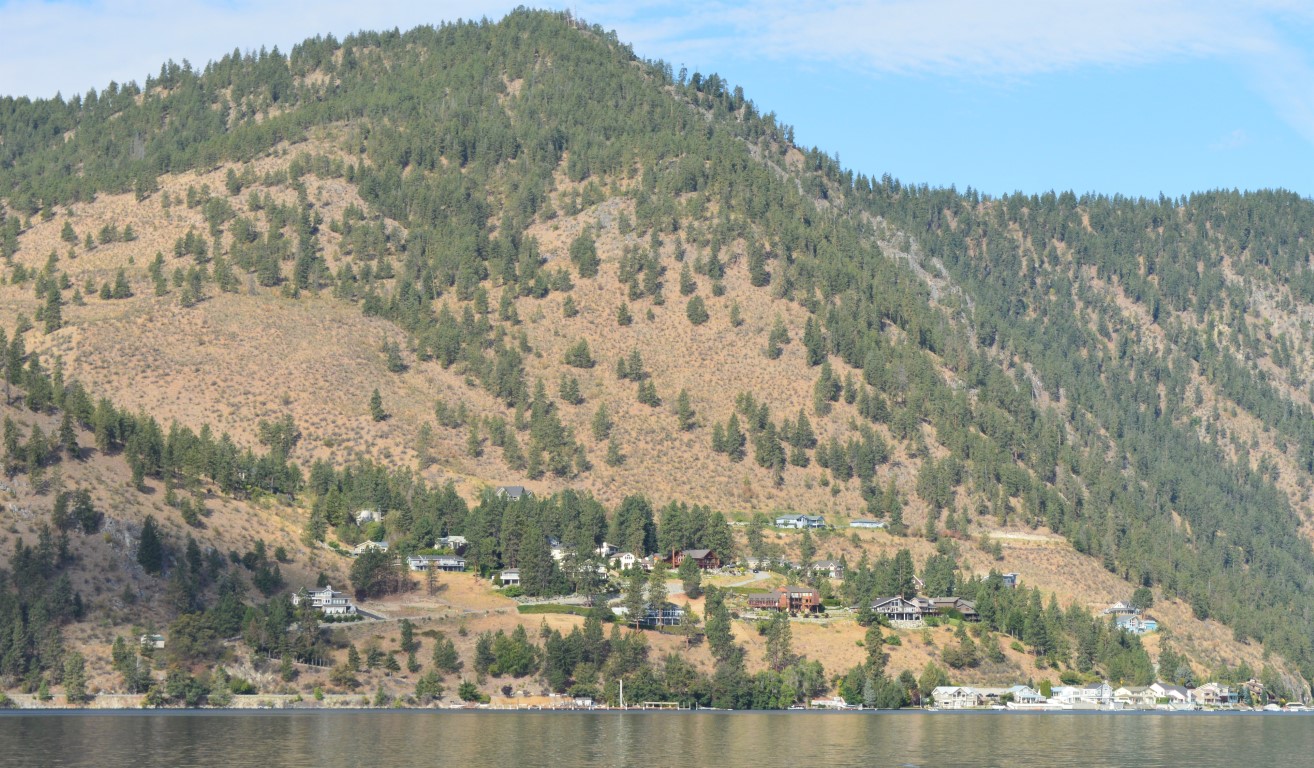
Both sides of the lake for the first part of the trip show signs of development.
Houses ranges in size from BIG to small line the banks.

Chelan (the city) averages only 11.4 inches of rain per year and 21.8 inches of snow. Stehekin (city at the north end) receives an average of 35.5 inches of rain and 122.5 inches of snow per year.

Although the land could technically be called desert, irrigated apple orchards and vineyards are everywhere.


The narrows and the place where development ends and wilderness takes over.


“Lady of the Lake” is a ferry and freight service that makes year-round trips the length of lake Chelan into the heart of the lake Chelan wilderness. From the boats, Lady I & Lady II, you can see the surrounding North Cascades peaks in excess of 9000 feet and 55 miles of beautiful shoreline. 

We chose to book a combination day-package which included riding Lady I up to Stehekin and Lady II on the return with a 3-hour layover for lunch and sightseeing in between.

Hikers, freight and commuters rely on Lady of the Lakes.

A stop on the way up to drop off freight and hikers.


The name "Stehekin" (stek-an) is based on an Indian word meaning "the way through." The Stehekin valley has long served as a passageway for travelers, linking Washington’s interior wilderness to the rugged Cascade Mountains. 


There are no roads that lead to Stehekan. There’s a road about 13 miles long that runs up the valley, but the only way in or out is by boat, float plane, or hiking. 


A ranger told me that that the numerous vehicles in the valley have been brought in by barge starting in the 70’s. Many look that old!


Look for the small cabin along the lakefront.


Snow capped mountains in the high Cascades.

A kayaker way out here. Must be my sister!


Besides the two Ladies I've mentioned
there is a fast catamaran that also makes a daily trip up & down the lake. 


On the return trip, the boat was slower and the wind was blowing from aft so the flag was flying backwards from our direction of travel. (??)


It was getting warm and the trip was near an end. Someone was getting sleepy sitting in the sun.


Our excursion was very enjoyable, but LONG. We left Okanogan at 7 a.m. to make the boat departure and didn’t get back to Chelan until 6:30 p.m. We chose to have a pleasant dinner in Chelan before we headed home, so it was almost 9 by the time we got back to Okanogan. 

A great time was had by all! Highly recommended! 

Thursday, July 30, 2020

Grand Coulee Dam


I didn't have an airplane handy to take this picture. I borrowed it.
Grand Coulee Dam (gold star on the map) is a concrete gravity dam built on the Columbia River in Washington, state. 


Grand Coulee is the largest power producing facility in the United States at 6,809 MW. 


The next 3 pictures are the dam as viewed from left to right


It was built to produce hydroelectric power and provide irrigation water.
Constructed between 1933 and 1942.

The dam originally had only two powerhouses, but a third powerhouse was completed in 1974 to increase energy production.

Visitors Center (closed by Covid-19)


We are camped at Okanogan, the blue dot /green flag on the map. 

Currently our tow vehicle (2010 F-350 dually) is in the shop for repairs. 

We'll enjoy the Okanogan Valley and Washington "apple country" for a few more weeks before we are again able to mosey on down the road to the Pacific coast.


Wednesday, July 22, 2020

"Pend Oreille" What?


Pend Oreille” is the french spelling of a beautiful big lake in the panhandle of Idaho. 


We were camped in the Bonner County Fairgrounds Campground (botton star on the map)  in Ponderay, ID on the shores of Lake Pend Oreille. 


Ponderay is the way you say that french name in English. 


The campground was clean, organized and a great place to relax and meet new RV friends. 


Ponderay and its neighboring city, Standpoint, made a great "base camp" for exploring northern Idaho and just relaxing in great weather and beautiful surroundings.


Schweitzer Mountain (top star on the map) is a nearby ski resort up in the mountains. 


Bayview, ID is nestled along the southern shores of Lake Pend Oreille and is primarily one huge marina, state park and "touristy stuff."


The Boat House is a great place for a relaxing and delicious supper.


Bayview is also the home of the Navy's Acoustic Research Detachment (ARD) because Lake Pend Oreille is Idaho’s largest, deepest (1,150 feet), and quietest body of water making it an ideal environment for acoustic testing. "The ARD operates and supports unique Large Scale Submarine Models, Test Ranges, and acoustic test facilities utilized in conducting Research, Development, Test & Evaluation (RDT&E) of submarine acoustic stealth technology."

Lake Pend Oreille offers over 200 miles of beautiful fresh water shoreline and stretches over 43 miles from Bayview to Sandpoint. 

Lake Pend Oreille, in the northern Idaho Panhandle is the largest lake in Idaho and the 38th-largest lake by area in the United States, with a surface area of 148 square miles and the fifth-deepest in the nation.


On a window in downtown Sandpoint.
On the window over a door in downtown Sandpoint


We absolutely loved our time in Idaho and will happily return in the future!


Saturday, July 11, 2020

Grant-Kohrs Ranch


On our route over to Idaho from Missouri Headwaters we discovered a unique National Historic Site, the Grant-Kohrs Ranch. 

We had a relatively easy day of travel planned, so we decided to stop & enjoy whatever the ranch had to offer. 


The Grant–Kohrs Ranch National Historic Site was created in 1972 to highlight the Western cattle industry from its inception in the 1850s through recent times.


The original ranch was established in 1862 by a Canadian fur trader named Johnny Grant at Cottonwood Creek, Montana, along the banks of the Clark Fork river. We drove beside the Clark Fork for much of our way to Standpoint, ID on route 93.

The ranch was later expanded by a cattle baron named Conrad Kohrs. 


The 1,618 acres historic site is maintained today as a working ranch (including livestock, of course) by the National Park Service. 


The various building contain many interesting artifacts of the golden-years of the ranch. The parking lot is big enough for even big rigs. 


We spent several very enjoyable hours on the Ranch before mosey'n on down the road toward Plains, MT where we would rest for a couple nights.